
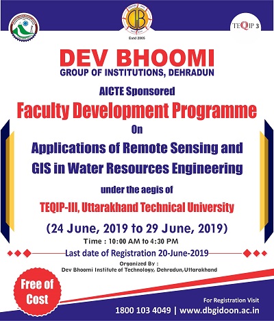
Faculty Development Programme on Applications of Remote Sensing and GIS in Water Resources Engineering.
ABOUT EVENT
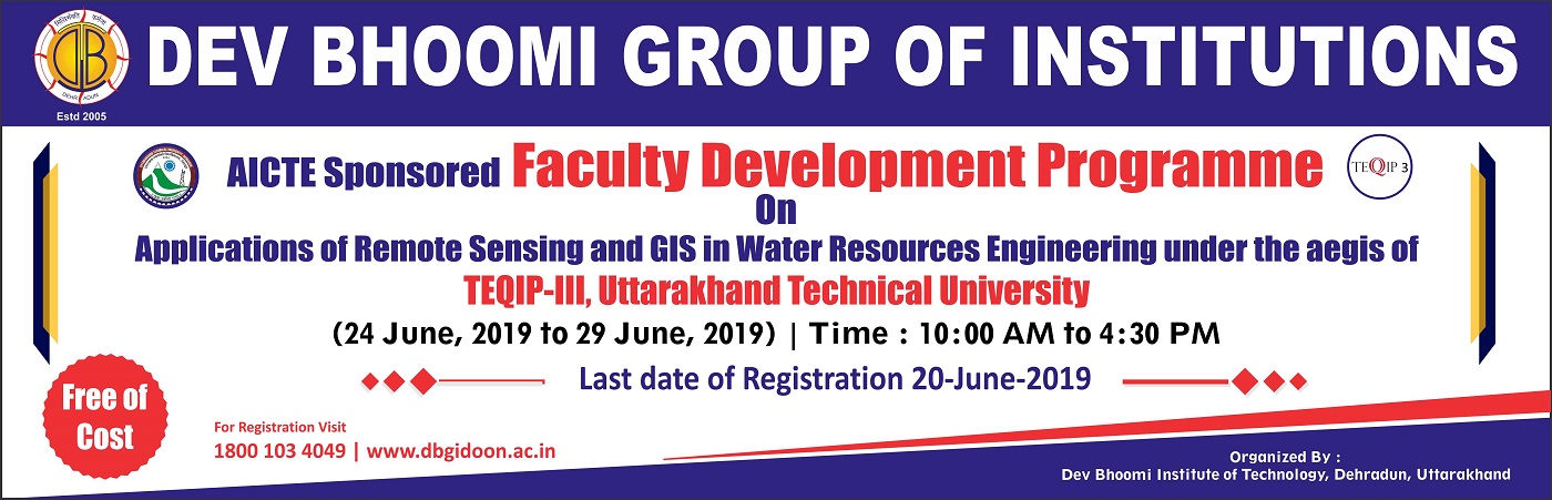
AICTE sponsored Faculty Development Programme
under the aegis of
TEQIP-III, Uttarakhand Technical University
on
Applications of Remote Sensing and GIS in Water Resources Engineering.
About FDP
A geographic information system (GIS) is a computer-based tool for mapping and analyzing feature events on earth. GIS technology integrates common database operations, such as query and statistical analysis, with maps. GIS manages location-based information and provides tools for display and analysis of various statistics, including population characteristics, economic development opportunities, and vegetation types. GIS allows you to link databases and maps to create dynamic displays. Additionally, it provides tools to visualize, query, and overlay those databases in ways not possible with traditional spreadsheets. These abilities distinguish GIS from other information systems, and make it valuable to a wide range of public and private enterprises for explaining events, predicting outcomes, and planning strategies. .
Remote sensing is the art and science of making measurements of the earth using sensors on airplanes or satellites. These sensors collect data in the form of images and provide specialized capabilities for manipulating, analyzing, and visualizing those images. Remote sensed imagery is integrated within a GIS.
Objectives
- To understand the principles, applications, trends, and pertinent issues of geographical information systems and sciences, including remote sensing (RS), Photogrammetry, cartography, and global positioning systems (GPS).
- To provide learning and teaching experiences with real world problems.
- To develop technical skills and competence in data and information acquisition, extraction, management and analysis; spatial and statistical modelling; mapping and visualization.
- To increase awareness of GIS and modelling tools for improving competition and business potential.
- To describe how geographical information is used, managed, and marketed globally.
- To gain an understanding of how to manipulate and apply vector and raster spatial data, particularly with regard to local/state/national issues, emphasizing lands in and near it.
- To develop applications of environmental remote sensing and GIS which can directly enhance service delivery on land use management, ground water management/prospects, agriculture, forestry, food and water security, disaster management, etc.
Programme Details |
|
| 01 | Duration: 6 Days |
| 02 | Program Date 24-29 June 2019 |
| 03 | Timings: 10:00 AM – 04:30 PM |
| 04 | Organized By : Dev Bhoomi Institute of Technology, Dehradun,Uttarakhand |
| 05 | To know more, contact:
Prof.(Dr.) Omprakash Netula +91- 9414966589 |
| 06 | Training Fee Free |
Resource Persons
Ajanta goswami
Assistant professor
Department of earth sciences
Associated faculty – coedmm
(center of excellence in disaster mitigation & management)
Indian institute of technology Roorkee
Uttarakhand, India,
Dr. Priyadarshi Upadhyay, Scientist/Engineer ‘SD’
Uttarakhand Space Application Centre
Department of Science & Technology (Government of Uttarakhand)
Dr Anil Kumar
Head PRSD & Scientist/Engineer- SG
Photogrammetry and Remote Sensing Department
Indian Institute of Remote Sensing ISRO,Govt. of India
Minakshi Kumar, Scientist/Engineer – SG
Photogrammetry and Remote Sensing Department
Indian Institute of Remote Sensing ISRO, Govt. of India
Mr Shashank Lingwal
Scientist / Engineer – ‘SC’
Uttarakhand Space Application Centre
Dehradun, Uttarakhand, India
| S. No | Name of the Expert(s) | Present Designation | Present Affiliation |
Qualification |
Schedule |
| 1 | Dr. Ajanta Goswami |
Associate Professor
|
Department of Earth Sciences Associate Professor Indian Institute of Technology, Roorkee |
PhD |
24/6/19 FN |
| 2 | Dr. Bhaskar R. Nikam | Sci./Eng. ‘SE’ | Water Resources Department Indian Institute of Remote Sensing | Indian Space Research Organisation, Department of Space | Govt. of India |
PhD |
24/6/19 AN |
| 3 | Er. Suman Gurjar | Scientist – C | Department of Ground Water Hydrology, National Institute of Hydrology, Roorkee |
M.Tech |
25/6/19 FN |
| 4 | Mr. Nitesh Patidar | Scientist – C | Department of Ground Water Hydrology, National Institute of Hydrology, Roorkee |
M.Tech |
25/6/19 AN |
| 5 | Dr. Laxmi Narayan Thakural | Scientist C | Department of Surface Water Hydrology, National Institute of Hydrology, Roorkee |
PhD |
26/6/19 FN |
| 6 | Dr. Vaibhav Garg | Scientist/Engineer ‘SE’ | Department of Water Resources, Indian Institute of Remote Sensing, Dehradun |
PhD |
26/6/19 AN |
| 7 | Dr. Anil Kumar Lohani | Scientist G | Department of Surface Water hydrology, National Institute of Hydrology, Roorkee |
PhD |
27/6/19 FN |
| 8 | Dr. Anil Kumar Lohani | Scientist G | Department of Surface Water hydrology, National Institute of Hydrology, Roorkee |
PhD |
27/6/19 AN |
| 9 | Dr. S.P.Aggarwal | Scientist/Engineer “SG” | Group Head, Water Resources Department Indian Institute of Remote Sensing Dehradun |
PhD |
28/6/19 FN |
| 10 | Dr. S.P.Aggarwal | Scientist/Engineer “SG” | Group Head, Water Resources Department Indian Institute of Remote Sensing Dehradun |
PhD |
28/6/19 AN |
| 11 | Dr. Sanjay Kumar Jain | Scientist G | Department of Water Resources System National Institute of Hydrology Roorkee |
PhD |
29/6/19 FN |
| 12
|
Dr. Santosh M. Pingale | Scientist C | Department of Hydrological Investigation National Institute of Hydrology Roorkee |
PhD |
29/6/19 AN |